

 Corregidor served as a fortress; an early warning outpost to warn Manila of any hostile ships; a customs outpost; and a correctional (prison). Because of the corrective effect of hard labor on prisoners, the island was named Corregidor, from the Spanish word "corregir" meaning the corrector. Corregidor is also known as "the rock" because of its rocky landscape and heavy fortifications.
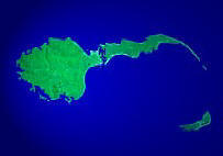
 Corregidor island is approximately 4 kilometers long, 1.5 kilometers at its widest and a total area of approximately 3 square miles. At the tip of the tail, 2 kilometers south, lies Caballo island. Both Corregidor and Caballo islands are part of the province of Cavite.


The tunnel had been dug through solid rock and offered complete protection from artillery or air attack. Command communications and medical units were located there. Gen. MacArthur set up the headquarters of USAFFE inside the tunnel where men and women would live and work during the siege of Corregidor. The tunnel was originally designed to house huge quantities of ammunition, food and supplies, and an underground hospital with a 1,000-bed capacity. The location of the tunnel beneath Malinta Hill made it ideal as a bomb-proof headquarters for the embattled Filipino and Americans defenders of Corregidor during World War II. During the siege of Corregidor, a number of shops and storage areas were added.
No comments:
Post a Comment